
Have you ever stumbled across a website that made your jaw drop? That caused you to wonder, “How have I never found this before?”
Thanks to City of Austin Parks and Recreation Department’s Allison Hardy, I discovered a wonderful resource that every outdoor enthusiast in Austin should have bookmarked.
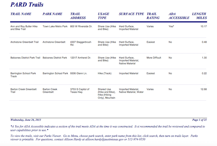
How Long Is the Barton Creek Greenbelt Trail?
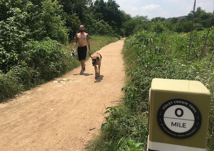
Alexander Banach and Hendrix end their walk at the Zilker trailhead. The 0 marker does double duty. It’s for the Violet Crown Trail (shown) as well as the Barton Creek Greenbelt Trail (the map and sign are located on the side facing Banach). (Credit: Leah Nyfeler)
Quick answer: Point-to-point, the Barton Creek Greenbelt trail is 7.5 miles, but the total amount of Austin Parks and Recreation Department-maintained trail totals 12.68 miles.
This question started with a debate about the trail running through the Barton Creek Greenbelt. As a trail running enthusiast, I’ve made the “round trip” (one end to the other and back) many times. I’ve seen the signs counting off each quarter mile from the 0-mile marker at the Zilker trailhead to the 7.5-mile marker near the top of the Hill of Life at the Camp Craft trailhead.
It’s pretty hard to argue with those signs, yet the City of Austin’s official web page lists the length at 12.68 miles. Yes, there is additional distance from several trailheads to main trail, but an additional five miles? Nah. What was I missing?
Curious, I reached out to the contact at the bottom of the park directory page: Allison Hardy, GIS Analyst Senior. I emailed Hardy to ask if she could explain the discrepancy between the trail markings and the City’s listing.
When we talked, Hardy explained that I was right; from one end point to the other end point, users would travel 7.5 miles. But 12.68 is right, too. The longer distance includes all available trail–including any paths to reach the main trail from various trailheads, as well as sections where pedestrians are separated from mountain bikers (those parallel trails effectively double that distance). Aha! Hardy also reminded me that a section of trail runs simultaneously on both sides of the creek. When all Parks and Recreation Department-maintained trail is added up, it totals 12.68 miles.
Then Hardy asked, “Do you have a minute? Can I show you something?”
Who reads the fine print? Note that, in addition to Hardy’s contact information, there are directions to what is described as the “Parks Viewer.”
As Hardy guided me to her department’s home page, I admit to giving a mental shrug and thinking, “Yeah, yeah, I know this,” as I’ve often steered people there to the Parks and Recreation Department’s comprehensive trail directory. She asked me to scan the list of links at the top of the page for “GIS” (Geographic/Geospacial Information Systems). This is Hardy’s baby. For years, she has been collecting data on Austin’s trails, parks, and amenities and then plotting the information into this system.
When I clicked on “Facility Services and 311 Mapping Application,” Hardy blew my mind.
Are There Restrooms Along the Barton Creek Greenbelt?
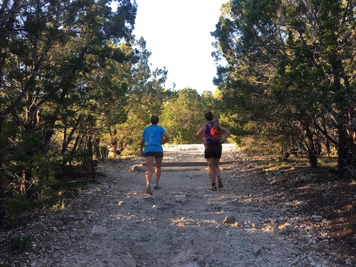
The Hill of Life is a popular training location for runners and hikers. These trail runners make their way uphill after an evening workout. (Credit: Leah Nyfeler)
Quick answer: Yes, there are four composting toilets. Two are a short distance from the bottom of the Hill of Life, another is near the Spyglass entrance and one is at the 360 trailhead, which is not noted on the map.
The interactive map feature allows users to access a wide variety of data and answer questions like:
- Where are amenities, such as restrooms, public art displays, volleyball courts, water fountains or benches?
- What about whether or not a facility is accessible for those with mobility issues?
- Can I locate a trashcan or some Mutt Mitts (disposable dog poop bags)?
- Where is the city mowing next?
- Is there a community garden located nearby?
One of the really cool aspects of the map is the ability to zoom in using the “aerial base map mode” (click on the cluster of four squares in the left-hand corner). It gives a bird’s eye view of the city and its outdoor treasures.
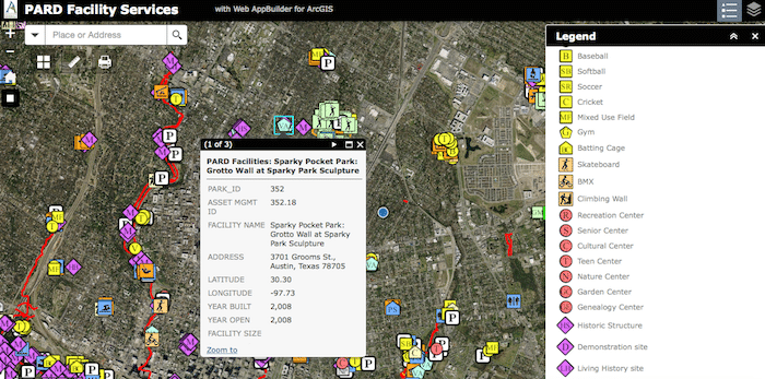
Note the highlighted icon for Visual Arts/Crafts. The box opened at left gives details. The interactive map legend is open to the right.
For example, type “Barton Creek Greenbelt” into the white search bar near the left-hand corner. If “street base map” has been chosen, the trail will be shown in relation to the city streets. The trail itself is delineated in red, signifying it’s a shared use public trail.
There will be a plethora of other items noted. Use the legend (upper right-hand corner, with icons of shapes and lines) to see what the various symbols mean. There is a bench located approximately midway between the Camp Craft trailhead sign and the Gains/MoPac sign. By clicking on the Camp Craft kiosk symbol, several boxes of information can be opened, informing (among other things) that the Hill of Life is .41 miles long and its terrain is rated “Most Difficult.” Click on the Gains/MoPac kiosk icon to learn there are 2.46 miles between the picnic table near the Hill of Life and the access to the parking area near the kiosk.
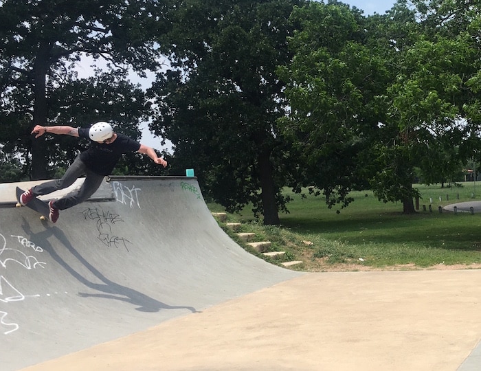
Joshua Boudreaux enjoys skateboarding at Patterson Park near his house. There are several skateboard facilities located around Austin in various parks. (Credit: Leah Nyfeler)
Another nifty feature Hardy pointed out is the ability to use this interactive map on a smartphone. Click on the locator to show your exact position, and the interactive map becomes a handy navigation tool.
If a user comes to a trail that is not noted, then it’s not part of the official Barton Creek Greenbelt trail. For example, if you walk down the Hill of Life, there is a trail to the left (popularly called “Rudy’s Loop,” it also leads to the old truck) and further down, another to the right (a longer, more twisting route leading to the dam). Parks and Recreation Department does not maintain either of these trails, so they do not appear on the map. Hardy pointed out that referencing the interactive map ensures users stay on the official Barton Creek Greenbelt trail.
Why Is Just Some of the Violet Crown Trail Marked on the Interactive Map?
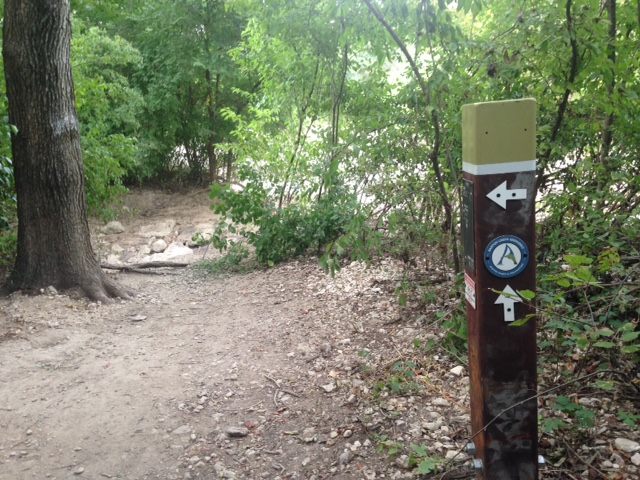
The marker points to the new Violet Crown Trail section as we look ahead to the dip in the greenbelt trail. With Austin’s recent rainfall, the creek is high and that dip is full of water. Parks and Recreation Department’s interactive map of the Barton Creek Greenbelt trail shows creek crossings. (Credit: Leah Nyfeler)
Quick answer: the Violet Crown Trail is marked at the beginning, where it and the Barton Creek Greenbelt are one and the same, because Parks and Recreation Department maintains that section. Different agencies, such as the Hill Country Conservancy, maintain other segments of the Violet Crown Trail, so those pieces are not marked on the map. [Note: after publication, I learned that, through an agreement with Parks and Recreation Department, Hill Country Conservancy has assumed maintenance of the Barton Creek Greenbelt trail from the 0 marker until the Violet Crown Trail diverges. That’s more than four miles of trail upkeep! Improvements are planned, so please support Hill Country Conservancy’s capital campaign.]
Hardy has spent long hours working to assimilate this resource (the aerial base has been available since 2012). Take a close look at the information in the pop-up boxes. Notations of “created by” and “modified date” are marked with “hardya.” Hardy personally investigates, notes and updates each item.
There’s a wealth of information available here, and I can honestly say I’ve spent hours checking out the outdoor resources around town. At home on my laptop, I had fun looking at the aerial base map to coordinate that overhead view with what I know about the Greenbelt from experience on my feet. And I scanned the map for sneak peeks of trails I’d yet to experience.
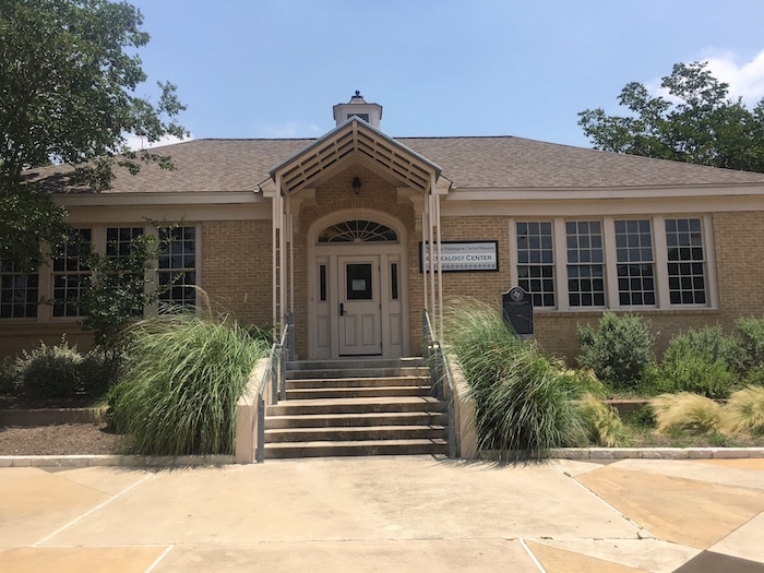
It’s not just about trails. The Genealogy Center, an extension of George Washington Carver Museum and Cultural Center on Angelina Street, is one of the historical buildings noted on Parks and Recreation Department’s interactive map. (Credit: Leah Nyfeler)
Who knew Austin had so many volleyball courts? I’ve never seen equestrian police patrolling on the Greenbelt, but I see they do. There are new places in parks to explore: a scenic overlook in Bartholomew, the hike and bike trail at Mabel Davis and an amphitheater in Rosewood.
Help Update Interactive Map of Austin Trails and Parks
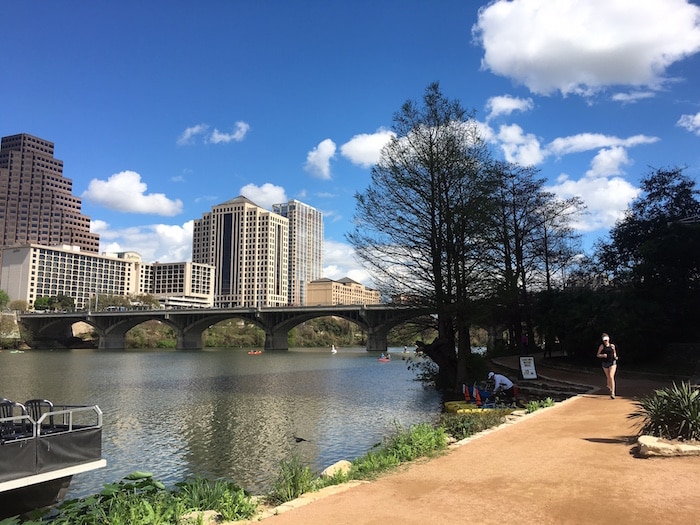
Find your way around Austin’s Lady Bird Lake by following the route. Parks and Recreation Department’s interactive map shows restrooms, benches, art work, scenic overlooks and more. (Credit: Leah Nyfeler)
If you’re using the interactive map and notice a discrepancy or problem, send Hardy a note at Allison.Hardy@austintexas.gov. Perhaps a picnic table has been removed, a new splash pad built, accessibility improved, a bathroom left off or Mutt Mitts added along your neighborhood trail. Let her know. Also, Hardy’s interested to hear if there’s any difficulty with the platform loading (it happens sometimes). Hardy is constantly tinkering with her page, making updates and improvements, and ironing out issues.
Use it, share it and pass along information. Together, we can help Hardy and Parks and Recreation Department build an interactive map that makes all of Austin’s beautiful outdoor amenities known with a click.
@Leahruns100 wants to know:
What’s one new thing you’ve discovered about Austin trails and parks from the interactive map?
- X Games, ROT Rally Provide Flat-Track Racing Fix - June 6, 2016
- X Games and Austin Share a Sweet Goodbye - June 2, 2016
- Austin Trails and Parks Revealed With Indepth Interactive Map - May 12, 2016
Same data but a different approach to the visualization is Austin Green Map, made by volunteers.
http://www.open-austin.org/austingreenmap/
Thanks for sharing that info, @openaustin:disqus. I’ll be sure to check that out, too. I love a great resource!
Hello, this map looks really nice but, sadly on my Mac it’s unusable. I think the zoom in/out has been hijacked and is to sensitive to be usable.
Huh. I have a Mac and didn’t have those problems with zoom. Let Hardy know — all feedback is helpful, especially stuff that relates to problems. Can’t fix what you don’t know about!
Meanwhile while when I type dog poop or dog poop bags I get: “Poop, Tixcacalcupul, Yucatán”
When all you gotta do is install of these things. http://crownproductsonline.com/family/poopy-pouch/pet-waste-stations/
FYI: those dog poop bag dispensers are called Mutt Mitt by PARD and show up automatically on the map (little gray dog icon).
Just a reminder: if the gates are closed at the Barton Creek Greenbelt trailheads, please be safe and respect the trail closure. There are two primary reasons why the greenbelt closes: flooding and extremely muddy trails. Flash floods and high, fast creek flow are life-threatening, and foot and bike traffic can really destroy a saturated and muddy trail.
I can’t find the trails mapping app you talk about in my phone’s app store. is there one?
@celsa, as far as I know, this is not an actual phone app. It’s a website: http://austin.maps.arcgis.com/apps/webappviewer/index.html?id=c069f13f4f1a4260b8694a2cb30b5880.